Photo Gallery — Greater Cincinnati Area
Introduction
Below are some photographs to help you better understand the geology of the tri-state region. Feel free to browse through the photographs and illustrations, but please respect our copyright. If we have a photo in our gallery that is not properly credited, please let us know. Also, we are always in search of historic photographs that shed light on the geology and prior land use in the Greater Cincinnati area of Ohio, Kentucky, and Indiana. If you have old photographs we would enjoy hearing about them, please don’t hesitate to contact us. Please enjoy our photo gallery.
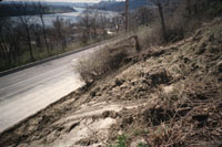
Licking River, Northern Kentucky- Site of a large embankment landslide on the Licking River  in Northern Kentucky near Route 9. Damages are to the sanitary sewer line which has been relocated above grade and to two international commercial businesses located upslope. The landslide is moving from left to right in the photo. Note the kink in the pipe that was originally laid straight and the visually off center concrete pads that act as supports for the pipe. The landslide has moved differentially causing the kink in the pipe. The landslide extends from the sewer man hole cover in the foreground to past the structure located in the background of the photograph. The landslide probably predates the present commercial development. Landslides of this size often get overlooked in the intial site development process. This photograph made the cover of Environmental and Engineering Geology magazine in 2007. Photo credit: T. Agnello. (click here for more pictures of this site)
Huffman Court, Cincinnati, Ohio- Huffman Court is a classic locality for landslides related to glacial lake clays. Cut-and-fill grading was initiated in 1961, but abandoned in 1962 when sliding of the western end of the street appeared. The new developer began work in 1971, underwritten by the U.S. Department of Housing and Urban Development. Material was removed from the uphill side of property and placed on the downhill side to make a flat building pad. Sliding began almost immediately, and three houses at the eastern end of the property were lost. Subsequently two additional houses in the center and western end have been removed. The landslidng on this street is rotational slumping and translational block glide movement riding on soft lake clay. (more pictures)
Lawyers Pointe, Anderson Township, Hamilton County, Ohio- This was a deep-seated slide in glacial material. The controlling surface of failure was a bed of glacial lake clay, but secondary failures have moved up through overlying tills. The original movement of the lake clay was probably triggered by downcutting of the creek at the foot of the hill. Thus this was an ancient landslide and the signs of landsliding should have been observed during initial site investigation before the development was begun. Because the main failure surface was so deep, conventional soil borings would not have revealed the problem, but inspection of aerial photographs in combination with an examination of the creek bed would have shown the problem. (more pictures)
Columbia Parkway, Cincinnati, Ohio- Landslides are a regular occurrence along Columbia Parkway. Common along the Parkway are thin landslides that travel as long sheets. Engineers and geologists refer to this variety of ground movement as translational landslides. These slides are usually associated with close proximity (thin landslides) to the Kope Formation, a mudstone rich rock unit of Ordovician age. The bedrock itself does not fail, instead it is the break down of the mudstone into clay near the surface of the unweathered bedrock that moves. The thickness of the displaced mass is typically less than six feet thick. Accordingly property damage is less severe than with other types of landslides. Movement can be very quick, often overnight. (more pictures)
Mt. Adams, Cincinnati, Ohio- Mt. Adams, named after President John Quincy Adams, is the most prominent topographic feature in Cincinnati. It is also home to one of the most expensive landslide remediation projects in the history of the U.S. The cost of remediation was $44.5 million in 2005 dollars. A normal retaining wall for this slide could not be used because the failure surface was too deep. The concrete piers adjacent to the I-471 cloverleaf are tied back into the bedrock with a series of cables that terminate in a bedrock tunnel that parallels the pier wall. (more photos)